A stormy pattern is unfolding during this holiday week. The first event is obvious – if you’ve looked outside. Showers are spreading across the Commonwealth with this speedy, tidy weather system. All told, a beneficial .1 to .4 inches of rain is in store, with showers exiting after 3 to 4 p.m. Tuesday afternoon. Temperatures will attempt to mount a recovery, but for many of us, this will be a raw day with highs that struggle to make 50 degrees.
No doubt many will be scrambling Wednesday to take advantage of the pleasant, dry weather. We’re seeing highs again near 50 with a steady breeze and plenty of sunshine. No travel issues on this day!
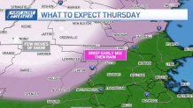
That’s a stark contrast to Thanksgiving. Rain will hit early and stay late. The storm is stronger, bringing wind gusts to 40 mph along the coast. The timeline and expectations read like this:
Rain will start in the early to mid-morning. Although some brief mix is possible on the outer Pike and northern end of I-495, it looks like it will turn to rain quickly. Holdouts include towns and cities north and west of Leominster. It’s here that we could see more significant accumulation as the storm cranks through midday and into the afternoon. Travel here may be tricky in the higher terrain.

Gusty winds will buffet the coast. Some may peak at 40 mph, but generally, this is simply a windy day from Cape Ann to Cape Cod. Elsewhere, we’ll be occasionally windy with gusts less than 30 mph.
Rainfall will top an inch in many spots. This will help chip away at the drought.
The storm will wrap in the early evening as steady rain tapers to sprinkles. Temperatures will hold in the mid and upper 30s into Friday morning. I’m NOT expecting a flash freeze Thursday night, but where it hovers near freezing in Greater Worcester, there may be some icy spots.
Cold, dry air will circulate in through the remainder of the holiday weekend and storms will steer clear of New England into next week.
Be safe, travel well, and enjoy your holiday weekend!
